C# 城市路网地图生成与运动模拟(一)-数据的获取
2015-01-14 00:00
246 查看
雪影工作室版权所有,转载请注明【http://blog.csdn.net/lina791211】
任务要求:
(1)通过一组城市路网街道的数据(图的格式存储,demo数据下面给),把城市路网数据转换成坐标数据(其实这一步,我拿到的数据已经转换完成了,也就是说我拿到了的是平面坐标数据,而不是球面经纬度数据);
(2)根据平面坐标数据,使用Java Swing或者Visual Studio(C# WinForm)生成城市路网;
(3)支持点击某点,以此点放大;
(4)支持按中心缩小
(5)不用考虑剪枝(城市路网地图放大是存在剪枝的,那是因为附加数据太多,我的demo中只有1W多个街道,内存完全无压力)
(6)经度不考虑(这个是因为winform坐标只能是整数,无法用浮点数表示)
(7)根据移动对象的移动数据,模拟移动对象的运动。
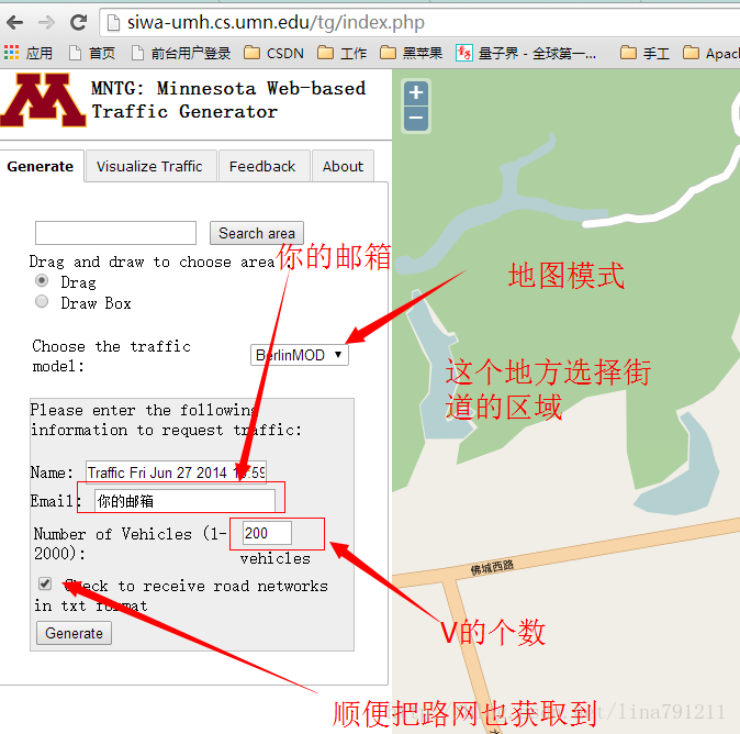
城市路网数据获取:来点我啊,来点我啊
然后过几天就会拿到数据了。
由于我这边通过其他途径得到数据的,所以还是简要介绍一下我这边数据的格式:
(1)街道数据
简要介绍下每行的含义
street编号,限速,Start X,Start Y,End X,End Y。
(2)移动对象数据
简要介绍下每行的含义
移动对象编号,暂无意义,开始时间,结束时间,Start X,Start Y,End X,End Y,暂无意义(其实是行驶路程),暂无意义(其实是平均速度)

(一)获取最大值最小值
实现机制很简单,读取文件,转换数据,比较大小,分别获取X与Y的最大值和最小值;
Convert.ToInt32(s1[2].Contains(".") ? s1[2].Substring(0, s1[2].IndexOf('.')) : s1[2]);的原因是:数据中有浮点数,,在粗粒度处理下,我就暴力的舍弃了。
从而得到XY的最大和最小值:
因此,我选择了form页面大小为900*700的。中心点是(450,350),xmin取-11000,ymin取-6800,坐标转换后需要的缩放倍率是50
(二)转换坐标,并保存文件
转换坐标好理解,保存文件是为了下次启动的时候可以直接读转换后的数据,而不用重新转换坐标了。其实这些都是数据的预处理。
里面涉及了坐标的转换,方法如下:
Form1_Load方法中直接调用对应的方法就行。

下一章讲述如何放大和缩小。
okay,本章结束!
1、前言
这段时间一直在研究城市路网,某一天受不可告人的启发,决定把城市路网的地图做出来,然后模拟移动对象在路网上的运动,故本人开始了模拟地图生成的不归路。任务要求:
(1)通过一组城市路网街道的数据(图的格式存储,demo数据下面给),把城市路网数据转换成坐标数据(其实这一步,我拿到的数据已经转换完成了,也就是说我拿到了的是平面坐标数据,而不是球面经纬度数据);
(2)根据平面坐标数据,使用Java Swing或者Visual Studio(C# WinForm)生成城市路网;
(3)支持点击某点,以此点放大;
(4)支持按中心缩小
(5)不用考虑剪枝(城市路网地图放大是存在剪枝的,那是因为附加数据太多,我的demo中只有1W多个街道,内存完全无压力)
(6)经度不考虑(这个是因为winform坐标只能是整数,无法用浮点数表示)
(7)根据移动对象的移动数据,模拟移动对象的运动。
2、数据demo
通过特殊途径拿到了一组城市路网街道的demo数据,如何拿到我就不讲了。但是可以提供另外一种获取途径。城市路网数据获取:来点我啊,来点我啊
然后过几天就会拿到数据了。
由于我这边通过其他途径得到数据的,所以还是简要介绍一下我这边数据的格式:
(1)街道数据
0,50,8209,8769,8293,8768
1,50,8293,8768,8594,8773
2,50,8594,8773,8982,8781
3,50,8982,8781,9222,8787
4,30,8982,8781,9057,8936
5,30,9057,8936,9106,9038
6,30,9106,9038,9163,9209
7,30,9163,9209,9211,9354
8,70,9222,8787,9227,8890
9,70,9227,8890,9248,9350
10,70,9248,9350,9280,9476
11,70,9280,9476,9334,9670
12,70,9334,9670,9387,9804
13,70,9387,9804,9444,9919
14,70,9395,10233,9401,10199
15,70,9401,10199,9444,10000
16,70,9444,9919,9444,10000
17,50,8594,8773,8598,9061
18,50,8595,9495,8598,9256
简要介绍下每行的含义
street编号,限速,Start X,Start Y,End X,End Y。
(2)移动对象数据
1	1	39:22.6	39:24.6	15537	3850	15537	3850	0	0
1	2	39:24.6	39:26.6	15537	3850	15541.5	3857	8.321658489	14.97898528
1	2	39:26.6	39:28.6	15541.5	3857	15550.3	3870.65	16.24076661	29.23337989
1	2	39:28.6	39:30.6	15550.3	3870.65	15559.4	3884.65	16.69760462	30.05568831
1	2	39:30.6	39:32.6	15559.4	3884.65	15565.5	3894.21	11.34035273	20.41263491
1	2	39:32.6	39:34.6	15565.5	3894.21	15574.4	3907.99	16.40421897	29.52759415
1	2	39:34.6	39:36.6	15574.4	3907.99	15583.5	3921.99	16.69760462	30.05568831
1	2	39:36.6	39:38.6	15583.5	3921.99	15592.5	3935.99	16.64331698	29.95797056
1	2	39:38.6	39:40.6	15592.5	3935.99	15601.6	3949.99	16.69760462	30.05568831
1	2	39:40.6	39:42.6	15601.6	3949.99	15610.6	3964	16.65172964	29.97311335
1	2	39:42.6	39:44.6	15610.6	3964	15619	3977.01	15.48612605	27.87502689
1	2	39:44.6	39:46.6	15619	3977.01	15625.7	3987.33	12.3041619	22.14749142
1	2	39:46.6	39:48.6	15625.7	3987.33	15634.7	4001.33	16.64331698	29.95797056
1	2	39:48.6	39:50.6	15634.7	4001.33	15643.7	4015.33	16.64331698	29.95797056
1	2	39:50.6	39:52.6	15643.7	4015.33	15652.8	4029.34	16.70598994	30.0707819
1	2	39:52.6	39:54.6	15652.8	4029.34	15661.8	4043.34	16.64331698	29.95797056
1	2	39:54.6	39:56.4	15661.8	4043.34	15670	4056	15.08362026	27.15051646
1	2	39:56.4	39:58.4	15670	4056	15663.1	4060.69	8.343027029	15.01744865
1	2	39:58.4	40:00.4	15663.1	4060.69	15649.7	4069.83	16.22034525	29.19662145
简要介绍下每行的含义
移动对象编号,暂无意义,开始时间,结束时间,Start X,Start Y,End X,End Y,暂无意义(其实是行驶路程),暂无意义(其实是平均速度)
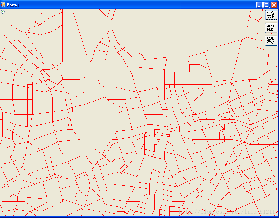
3、先上demo
讲了这么久,先把路网的demo拿出来看一下。(放大两倍后的,不敢把原图搞出来,不知道是否涉密)4、数据处理
手里拿到的路网数据,是平面坐标数据,而且起始范围特别大,用1366这样的范围根本不能忍。故要读取样本,获取X、Y的最大值、最小值,并获取区间范围,然后缩放坐标范围到1000以内就行。(一)获取最大值最小值
实现机制很简单,读取文件,转换数据,比较大小,分别获取X与Y的最大值和最小值;
/// <summary>
/// 测试使用
/// 获取坐标集合中X 、Y的最大值和最小值
/// </summary>
/// <param name="strs"></param>
private void getMax_Min_XY(string[] strs)
{
int xMin = 0;
int xMax = 0;
int yMin = 0;
int yMax = 0;
string[] s = strs[0].Split(',');
xMin = Convert.ToInt32(s[2]);
xMax = Convert.ToInt32(s[4]);
yMin = Convert.ToInt32(s[3]);
yMax = Convert.ToInt32(s[5]);
if (xMin < xMax)
{
int temp = xMin; xMin = xMax; xMax = temp;
}
if (yMin < yMax)
{
int temp = yMin; yMin = yMax; yMax = temp;
}
// Console.WriteLine("\txMax \txMin \tyMax \tyMin");
for (int i = 1; i < strs.Length; i++)
{
Console.Write("\n"+i);
string[] s1 = strs[i].Split(',');
int _xMin = Convert.ToInt32(s1[2].Contains(".") ? s1[2].Substring(0, s1[2].IndexOf('.')) : s1[2]);
int _xMax = Convert.ToInt32(s1[4].Contains(".") ? s1[4].Substring(0, s1[4].IndexOf('.')) : s1[4]);
int _yMin = Convert.ToInt32(s1[3].Contains(".") ? s1[3].Substring(0, s1[3].IndexOf('.')) : s1[3]);
int _yMax = Convert.ToInt32(s1[5].Contains(".") ? s1[5].Substring(0, s1[5].IndexOf('.')) : s1[5]);

if (_xMin < xMin)  xMin = _xMin;
else if (_xMin > xMax) xMax = _xMin;

if (_xMax < xMin) xMin = _xMax;
else if (_xMax > xMax) xMax = _xMax;

if (_yMin < yMin) yMin = _yMin;
else if (_yMin > yMax) yMax = _yMin;

if (_yMax < yMin) yMin = _yMax;
else if (_yMax > yMax) yMax = _yMax;

Console.Write("\t" + xMax);
Console.Write("\t" + xMin);
Console.Write("\t" + yMax);
Console.Write("\t" + yMin);
}
Console.WriteLine("xMax:" + xMax);
Console.WriteLine("xMin:" + xMin);
Console.WriteLine("yMax:" + yMax);
Console.WriteLine("yMin:" + yMin);
} 使用Convert.ToInt32(s1[2].Contains(".") ? s1[2].Substring(0, s1[2].IndexOf('.')) : s1[2]);的原因是:数据中有浮点数,,在粗粒度处理下,我就暴力的舍弃了。
从而得到XY的最大和最小值:
// private int xMax =33575;
// private int xMin=-10836;
// private int yMax=28095;
// private int yMin = -6686;
通过计算,xMax-xMin,yMax-yMin,离他们最近的最大整数分别是 90000和70000。
因此,我选择了form页面大小为900*700的。中心点是(450,350),xmin取-11000,ymin取-6800,坐标转换后需要的缩放倍率是50
private static int xmin = -11000;
private static int ymin = -6800;
private static int rate = 50;
private int _Xc = 450;
private int _Yc = 350;
这些数据都作为固定值保存下来。不能每次加载地图的时候都去处理一遍啊,是不?处理数据很慢的。
(二)转换坐标,并保存文件
转换坐标好理解,保存文件是为了下次启动的时候可以直接读转换后的数据,而不用重新转换坐标了。其实这些都是数据的预处理。
/// <summary>
/// 测试使用的,根据城市路网坐标数据,生成符合当前坐标的路网坐标
/// </summary>
private void ConvertStreetPoints()
{
string[] strs = System.IO.File.ReadAllLines("c://streets_seg.csv");
FileStream fs = new FileStream("C:\\A.txt", FileMode.Append);
StreamWriter sw = new StreamWriter(fs, Encoding.Default);
//Graphics g = this.pictureBox1.CreateGraphics();
for (int i = 1; i < strs.Length; i++)
{
string[] s1 = strs[i].Split(',');
//Console.Write("\n");
// Console.WriteLine(getX(s1[2]));
// Console.WriteLine(getX(s1[4]) );
// Console.WriteLine(getY(s1[3]) );
// Console.WriteLine(getY(s1[5]));

//sw.Write(text);

sw.Write(getX(s1[2]) + "\n");
sw.Write(getX(s1[4]) + "\n");
sw.Write(getY(s1[3]) + "\n");
sw.Write(getY(s1[5]) + "\n");
// Pen p = new Pen(Color.Red);
// Point a = new Point(getX(s1[2]), getY(s1[3]));
// Point b = new Point(getX(s1[4]), getY(s1[5]));
// g.DrawLine(p, a, b);
}
sw.Close();
fs.Close();
}
里面涉及了坐标的转换,方法如下:
/// <summary>
/// 转换路网坐标
/// </summary>
/// <param name="x"></param>
/// <returns></returns>
private int getX(String x)
{
int tmp = Convert.ToInt32(x.Contains(".") ? x.Substring(0, x.IndexOf('.')) : x);
return (tmp - xmin) / rate;
}
/// <summary>
/// 转换路网坐标
/// </summary>
/// <param name="y"></param>
/// <returns></returns>
private int getY(String y)
{
int tmp = Convert.ToInt32(y.Contains(".") ? y.Substring(0, y.IndexOf('.')) : y);
return (tmp - ymin) / rate;
}
处理后的坐标样式如下,每行一个数据,按照start X,end X,Start Y,End Y 进行保存的。当初脑子有点抽385 391 311 311 391 399 311 311okay,路网的数据就这样基本处理完成了,下面开始进行地图绘制操作了。
5、地图绘制
系统启动的时候,首先要把转换后的路网坐标数据存到内存中,(不要跟我说存神马R树啊之类的,内容太少,没必要)private int[] ax = new int[MAX]; private int[] ay = new int[MAX]; private int[] bx = new int[MAX]; private int[] by = new int[MAX];
/// <summary>
/// 初始化路网路口坐标
/// </summary>
private void initPoints()
{
string[] strs = System.IO.File.ReadAllLines("C:\\A.txt");
for (int i = 0; i < strs.Length/4; i++) {
//Console.WriteLine(strs[i]);
ax[i] = Convert.ToInt32(strs[i * 4]);

bx[i] = Convert.ToInt32(strs[i * 4 + 1]);

ay[i] = Convert.ToInt32(strs[i * 4 + 2]);

by[i] = Convert.ToInt32(strs[i * 4 + 3]);
}
}
然后剩下的就是A-B这样进行划线啦。so easy的!(给form添加一个paint事件)/// <summary>
/// 绘制地图主方法
/// </summary>
private void repaint()
{
Graphics g = this.CreateGraphics();
for (int i = 1; i < ax.Length; i++)
{
Pen p = new Pen(Color.Red);
Point a = new Point(ax[i], ay[i]);
Point b = new Point(bx[i], by[i]);
g.DrawLine(p, a, b);
}
}
/// <summary>
/// 绘制地图(Form的paint事件)
/// </summary>
/// <param name="sender"></param>
/// <param name="e"></param>
private void Form1_Paint(object sender, PaintEventArgs e)
{
repaint();
}Form1_Load方法中直接调用对应的方法就行。
private void Form1_Load(object sender, EventArgs e)
{
string[] strs = System.IO.File.ReadAllLines("c://streets_seg.csv");
//Console.WriteLine(strs.Length);
//ConvertStreetPoints();
//ConvertTripPoint();
initPoints();
// initTripPoints();
//getMax_Min_XY(strs);
//
}
6、地图出现
系统启动后会在1S左右把数据加载进来,然后绘制地图的图形,速度还是不错的。如果直接拿原始数据,先切割,再转换数据类型,然后缩放坐标点,这一套流程下来要耗费1分多的。下一章讲述如何放大和缩小。
okay,本章结束!

相关文章推荐
- C# 城市路网地图生成与运动模拟(一)-数据的获取
- 使用Socket通信实现Silverlight客户端实时数据的获取(模拟GPS数据,地图实时位置)
- C# 利用HttpWebRequest模拟登陆获取数据设置Accept-Encoding为gzip,deflate后返回的网页是乱码处理
- c#模拟表单POST数据,并获取跳转之后的页面
- ASP.NET MVC WebApi 返回数据类型序列化控制(json,xml) 用javascript在客户端删除某一个cookie键值对 input点击链接另一个页面,各种操作。 C# 往线程里传参数的方法总结 TCP/IP 协议 用C#+Selenium+ChromeDriver 生成我的咕咚跑步路线地图 (转)值得学习百度开源70+项目
- C# Rss 操作类 C#获取Rss数据 C#生成Rss文件
- PHP+openlayers实现的一个登陆校园卡网获取消费数据中地点生成个人运动轨迹的小DEMO
- 使用Socket通信实现Silverlight客户端实时数据的获取(模拟GPS数据,地图实时位置)
- 使用Socket通信实现Silverlight客户端实时数据的获取(模拟GPS数据,地图实时位置)
- 使用Socket通信实现Silverlight客户端实时数据的获取(模拟GPS数据,地图实时位置)
- C# 把数据集生成为JSON格式 并在使用Jquery 获取JSON数据
- C#也能动态生成Word文档并填充数据
- C#也能动态生成Word文档并填充数据
- C#也能动态生成Word文档并填充数据
- C#中使用byte[]数据,生成Bitmap(256色 灰度 BMP位图)源代码
- shawl.qiu c# .net 自动生成 OleDb 数据操作语句小工具 Producing OleDbSql 1.1
- 用C#动态生成Word文档并将数据填入Word表格中
- C# 数据绑定 控件信息的获取
- 用C#读取C/C++中struct数据类型生成的文件
- JS 生成 后台获取里面的值(C#)