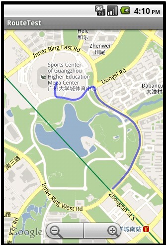
android在google map上画出导航路线图
2012-09-14 12:10
239 查看
android在google map上画线比较容易实现的,但是现在问题在于如何获取起点和终点之间的路线图。这里我们使用Google Directions API来实现, Google Directions API是一种使用 HTTP 请求计算多个位置间路线的服务。路线可以以文本字符串或纬度/经度坐标的形式指定起点、目的地和路标。Google Directions API 可以使用一系列路标传回多段路线。
Google Directions API 请求是以下形式的 HTTP 网址:http://maps.google.com/maps/api/directions/output?parameters
其中,output 可能是以下任何一个值:
json(建议)表示以 JavaScript 对象表示法 (JSON) 的形式输出
xml 表示以 XML 的形式输出
具体参数参见http://code.google.com/intl/zh-CN/apis/maps/documentation/directions/
通过http请求获取线路,接下来我们需要对返回结果进行解析,提取出导航线路的一系列路标。
如果我们只是简单的画图路线路,返回结果中的字段overview_path包含可我们所需要的数据。它包含一个对象,该对象包含一组表示生成路线的近似(平滑)路径的已编码 points 和 levels。编码算法参见http://code.google.com/intl/zh-CN/apis/maps/documentation/utilities/polylinealgorithm.html说明。
我们只需要提取points字段中的字符串进行解码就可以得到我们所需的一系列点了,将这些点按顺序连接起来就是我们所要的路线图了。
转载自 http://blog.csdn.net/ccgang/article/details/6328671
Google Directions API 请求是以下形式的 HTTP 网址:http://maps.google.com/maps/api/directions/output?parameters
其中,output 可能是以下任何一个值:
json(建议)表示以 JavaScript 对象表示法 (JSON) 的形式输出
xml 表示以 XML 的形式输出
具体参数参见http://code.google.com/intl/zh-CN/apis/maps/documentation/directions/
通过http请求获取线路,接下来我们需要对返回结果进行解析,提取出导航线路的一系列路标。
如果我们只是简单的画图路线路,返回结果中的字段overview_path包含可我们所需要的数据。它包含一个对象,该对象包含一组表示生成路线的近似(平滑)路径的已编码 points 和 levels。编码算法参见http://code.google.com/intl/zh-CN/apis/maps/documentation/utilities/polylinealgorithm.html说明。
我们只需要提取points字段中的字符串进行解码就可以得到我们所需的一系列点了,将这些点按顺序连接起来就是我们所要的路线图了。
/**
* 通过解析google map返回的xml,在map中画路线图
*/
public void drawRoute(){

String url = "http://maps.google.com/maps/api/directions/xml?origin=23.055291,113.391802" +
"&destination=23.046604,113.397510&sensor=false&mode=walking";

HttpGet get = new HttpGet(url);
String strResult = "";
try {
HttpParams httpParameters = new BasicHttpParams();
HttpConnectionParams.setConnectionTimeout(httpParameters, 3000);
HttpClient httpClient = new DefaultHttpClient(httpParameters);

HttpResponse httpResponse = null;
httpResponse = httpClient.execute(get);

if (httpResponse.getStatusLine().getStatusCode() == 200){
strResult = EntityUtils.toString(httpResponse.getEntity());
}
} catch (Exception e) {
return;
}

if (-1 == strResult.indexOf("<status>OK</status>")){
Toast.makeText(this, "获取导航路线失败!", Toast.LENGTH_SHORT).show();
this.finish();
return;
}

int pos = strResult.indexOf("<overview_polyline>");
pos = strResult.indexOf("<points>", pos + 1);
int pos2 = strResult.indexOf("</points>", pos);
strResult = strResult.substring(pos + 8, pos2);

List<GeoPoint> points = decodePoly(strResult);

MyOverLay mOverlay = new MyOverLay(points);
List<Overlay> overlays = mMapView.getOverlays();
overlays.add(mOverlay);

if (points.size() >= 2){
mMapController.animateTo(points.get(0));
}

mMapView.invalidate();
}
/**
* 解析返回xml中overview_polyline的路线编码
*
* @param encoded
* @return
*/
private List<GeoPoint> decodePoly(String encoded) {     List<GeoPoint> poly = new ArrayList<GeoPoint>();
int index = 0, len = encoded.length();
int lat = 0, lng = 0;     while (index < len) {
int b, shift = 0, result = 0;
do {
b = encoded.charAt(index++) - 63;
result |= (b & 0x1f) << shift;
shift += 5;
} while (b >= 0x20);
int dlat = ((result & 1) != 0 ? ~(result >> 1) : (result >> 1));
lat += dlat;         shift = 0;
result = 0;
do {
b = encoded.charAt(index++) - 63;
result |= (b & 0x1f) << shift;
shift += 5;
} while (b >= 0x20);
int dlng = ((result & 1) != 0 ? ~(result >> 1) : (result >> 1));
lng += dlng;         GeoPoint p = new GeoPoint((int) (((double) lat / 1E5) * 1E6),
(int) (((double) lng / 1E5) * 1E6));
poly.add(p);
}     return poly;
} public class MyOverLay extends Overlay {
private List<GeoPoint> points;
private Paint paint;

/**
* 构造函数,使用GeoPoint List构造Polyline
*
* @param points
*            GeoPoint点List
*/
public MyOverLay(List<GeoPoint> points) {
this.points = points;
paint = new Paint();
paint.setColor(Color.BLUE);
paint.setAlpha(150);
paint.setAntiAlias(true);
paint.setStyle(Paint.Style.FILL_AND_STROKE);
paint.setStrokeWidth(4);
}

@Override
public void draw(Canvas canvas, MapView mapView, boolean shadow) {
if (!shadow) {// 不是绘制shadow层
Projection projection = mapView.getProjection();
if (points != null && points.size() >= 2) {// 画线
Point start = new Point();
projection.toPixels(points.get(0), start);// 需要转换坐标
for (int i = 1; i < points.size(); i++) {
Point end = new Point();
projection.toPixels(points.get(i), end);
canvas.drawLine(start.x, start.y, end.x, end.y, paint);// 绘制到canvas上即可
start = end;
}
}
}
}
}
转载自 http://blog.csdn.net/ccgang/article/details/6328671

相关文章推荐
- android在google map上画出导航路线图
- android在google map上画出导航路线图
- android在google map上画出导航路线图
- android在google map上画出导航路线图
- android在google map上画出导航路线图
- android在google map上画出导航路线图
- android在google map上画出导航路线图
- android在google map上画出导航路线图
- android在google map上画出导航路线图
- android在google map上画出导航路线图
- Android学习进阶路线导航线路(Android源码分享)
- Android学习进阶路线导航线路(Android源码分享)
- Android学习进阶路线导航线路
- Android学习进阶路线导航线路(Android源码分享)
- Android定位&地图&导航——自定义公交路线代码
- android map (google map ,百度 ,高德 )在路线 上画箭头
- android直接调用google map的导航service
- Android学习进阶路线导航线路(Android源码分享)
- Android学习进阶路线导航线路(Android源码分享)
- 在android mapview控件里画简单导航路线的方法