Tiles in Google Maps:Coordinates、Tile Bounds and Projection
2012-07-16 20:40
471 查看
Click on a tile to display the numerical boundaries...
Addressing tiles: same tile bounds with different indexes
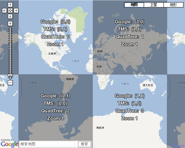
Google Maps, Microsoft Virtual Earth, Yahoo Maps, and other commercial API providers as well as OpenStreetMap and OpenAerialMap are using the same projection and tiling profile and tiles are therefore compatible. The extents of all tiles as well as the zoom levels (resolution in meters per pixel) are predefined for the whole Earth.
Difference is only in the way how the equivalent tiles are indexed. There are three main systems of tile adressing: Google XYZ, Microsoft QuadTree and from the open-source world comming TMS (Tile Map Service).
1.Google - described in the Google Maps API documentation
2.TMS an variant of Google tile addressing, which is used in open-source projects like OpenLayers or TileCache. This system is described in the OSGEO Tile Map Service (TMS) Specification
3.QuadTree - with documentation in the Virtal Earth Tile System from Microsoft
全文见:http://www.maptiler.org/google-maps-coordinates-tile-bounds-projection/
Addressing tiles: same tile bounds with different indexes
Google Maps, Microsoft Virtual Earth, Yahoo Maps, and other commercial API providers as well as OpenStreetMap and OpenAerialMap are using the same projection and tiling profile and tiles are therefore compatible. The extents of all tiles as well as the zoom levels (resolution in meters per pixel) are predefined for the whole Earth.
Difference is only in the way how the equivalent tiles are indexed. There are three main systems of tile adressing: Google XYZ, Microsoft QuadTree and from the open-source world comming TMS (Tile Map Service).
1.Google - described in the Google Maps API documentation
2.TMS an variant of Google tile addressing, which is used in open-source projects like OpenLayers or TileCache. This system is described in the OSGEO Tile Map Service (TMS) Specification
3.QuadTree - with documentation in the Virtal Earth Tile System from Microsoft

相关文章推荐
- Tiles à la Google Maps: Coordinates, Tile Bounds and Projection
- Tiles à la Google Maps: Coordinates, Tile Bounds and Projection
- SQLServer2005新增序列功能的几个函数:ROW_NUMBER, RANK, DENSE_RANK, and NTILE
- Code:Blocks and MinGW Configuration and Projection Integration based on WXWidget2.9.1
- OpenGL学习脚印: 投影矩阵和视口变换矩阵(math-projection and viewport matrix)
- Applying Projection and Camera Views 运用投影和相机视图
- Data Binding Android - Type parameter T has incompatible upper bounds : ViewDataBinding and MainActi
- MondoDB Query failed with error code 2 and error message 'Projection cannot have a mix of inclusion
- Collisions and Collectables: How To Make a Tile Based Game with Cocos2D Part 2
- [Angular] Configurable Angular Components - Content Projection and Input Templates
- J.M. Lopez: Minimum and maximum utilization bounds for Multiprocessor RM
- Isometric View and Isometric Projection
- Difference between frame and bounds
- iphone游戏开发-Collisions and Collectables: How To Make a Tile Based Game with Cocos2D Part 2
- Projection and camera view in OpenGL ES 1.0
- An intro to modern OpenGL. Chapter 3: 3D transformation and projection
- 缓存地图 ArcGIS ——Local compact and exploded tile cache layer for WPF API
- 论文阅读:Segmentation of teeth in CT volumetric dataset by panoramic projection and variational level se
- UIView frame, bounds and center
- Displaying Graphics with OpenGL ES(四)——Applying Projection and Camera Views