pku acm 1005 解题报告
2006-08-31 21:35
239 查看
问题描述:
I Think I Need a Houseboat
Time Limit:1000MS Memory Limit:10000K
Total Submit:16915 Accepted:5870
Description
Fred Mapper is considering purchasing some land in Louisiana to build his house on. In the process of investigating the land, he learned that the state of Louisiana is actually shrinking by 50 square miles each year, due to erosion caused by the Mississippi River. Since Fred is hoping to live in this house the rest of his life, he needs to know if his land is going to be lost to erosion.
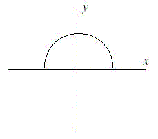
After doing more research, Fred has learned that the land that is being lost forms a semicircle. This semicircle is part of a circle centered at (0,0), with the line that bisects the circle being the X axis. Locations below the X axis are in the water. The semicircle has an area of 0 at the beginning of year 1. (Semicircle illustrated in the Figure.)
Input
The first line of input will be a positive integer indicating how many data sets will be included (N). Each of the next N lines will contain the X and Y Cartesian coordinates of the land Fred is considering. These will be floating point numbers measured in miles. The Y coordinate will be non-negative. (0,0) will not be given.
Output
For each data set, a single line of output should appear. This line should take the form of: “Property N: This property will begin eroding in year Z.” Where N is the data set (counting from 1), and Z is the first year (start from 1) this property will be within the semicircle AT THE END OF YEAR Z. Z must be an integer. After the last data set, this should print out “END OF OUTPUT.”
Sample Input
2
1.0 1.0
25.0 0.0
Sample Output
Property 1: This property will begin eroding in year 1.
Property 2: This property will begin eroding in year 20.
END OF OUTPUT.
Hint
1.No property will appear exactly on the semicircle boundary: it will either be inside or outside.
2.This problem will be judged automatically. Your answer must match exactly, including the capitalization, punctuation, and white-space. This includes the periods at the ends of the lines.
3.All locations are given in miles.
代码如下:
//Language: java Accepted Time: 2006/3/27

import java.io.*;
import java.util.*;


public class Main ...{


public static void main(String[] args) ...{

int n,i,j=0;
double r,area;
ArrayList<Double> xList = null;
ArrayList<Double> yList = null;
Scanner in = new Scanner(new InputStreamReader(System.in));
int count = in.nextInt();
xList = new ArrayList<Double>(count);
yList = new ArrayList<Double>(count);
for(i=0;i<count;i++)...{
xList.add(in.nextDouble());
yList.add(in.nextDouble());

}
for(i=0;i<count;i++)...{
j=i+1;
r = Math.sqrt(xList.get(i)*xList.get(i)+yList.get(i)*yList.get(i));
area = Math.PI*r*r;
n = (int)(area/100+1);
System.out.printf("Property %d: This property will"
+" begin eroding in year %d. ",j,n);
}
System.out.println("END OF OUTPUT.");
}

}
I Think I Need a Houseboat
Time Limit:1000MS Memory Limit:10000K
Total Submit:16915 Accepted:5870
Description
Fred Mapper is considering purchasing some land in Louisiana to build his house on. In the process of investigating the land, he learned that the state of Louisiana is actually shrinking by 50 square miles each year, due to erosion caused by the Mississippi River. Since Fred is hoping to live in this house the rest of his life, he needs to know if his land is going to be lost to erosion.
After doing more research, Fred has learned that the land that is being lost forms a semicircle. This semicircle is part of a circle centered at (0,0), with the line that bisects the circle being the X axis. Locations below the X axis are in the water. The semicircle has an area of 0 at the beginning of year 1. (Semicircle illustrated in the Figure.)
Input
The first line of input will be a positive integer indicating how many data sets will be included (N). Each of the next N lines will contain the X and Y Cartesian coordinates of the land Fred is considering. These will be floating point numbers measured in miles. The Y coordinate will be non-negative. (0,0) will not be given.
Output
For each data set, a single line of output should appear. This line should take the form of: “Property N: This property will begin eroding in year Z.” Where N is the data set (counting from 1), and Z is the first year (start from 1) this property will be within the semicircle AT THE END OF YEAR Z. Z must be an integer. After the last data set, this should print out “END OF OUTPUT.”
Sample Input
2
1.0 1.0
25.0 0.0
Sample Output
Property 1: This property will begin eroding in year 1.
Property 2: This property will begin eroding in year 20.
END OF OUTPUT.
Hint
1.No property will appear exactly on the semicircle boundary: it will either be inside or outside.
2.This problem will be judged automatically. Your answer must match exactly, including the capitalization, punctuation, and white-space. This includes the periods at the ends of the lines.
3.All locations are given in miles.
代码如下:
//Language: java Accepted Time: 2006/3/27
import java.io.*;
import java.util.*;
public class Main ...{
public static void main(String[] args) ...{
int n,i,j=0;
double r,area;
ArrayList<Double> xList = null;
ArrayList<Double> yList = null;
Scanner in = new Scanner(new InputStreamReader(System.in));
int count = in.nextInt();
xList = new ArrayList<Double>(count);
yList = new ArrayList<Double>(count);
for(i=0;i<count;i++)...{
xList.add(in.nextDouble());
yList.add(in.nextDouble());
}
for(i=0;i<count;i++)...{
j=i+1;
r = Math.sqrt(xList.get(i)*xList.get(i)+yList.get(i)*yList.get(i));
area = Math.PI*r*r;
n = (int)(area/100+1);
System.out.printf("Property %d: This property will"
+" begin eroding in year %d. ",j,n);
}
System.out.println("END OF OUTPUT.");
}
}

相关文章推荐
- POJ 1005I Think I Need a Houseboat解题报告——【PKU ACM】
- Pku acm 1157 LITTLE SHOP OF FLOWERS 动态规划题目解题报告(十四)
- Pku acm 2418 Hardwood Species 排序算法解题报告(六) ----二叉查找数(BST)
- POJ 1007DNA Sorting解题报告——【PKU ACM】
- 有向图的汇点 -- 兼 ACM PKU POJ 2186 ( Popular Cows ) 解题报告
- 单调队列 - 兼 ACM PKU POJ 3250 及 2823 解题报告
- pku 1005 解题报告
- Pku acm 2075 Tangled in Cables数据结构题目解题报告(十一)最小生成树:prim算法&amp;amp;二叉查找树
- Pku acm 1080 Humman Gene Function 动态规划题目解题报告(八)
- Pku acm 1088 滑雪 动态规划题目解题报告(十五)
- Pku acm 1002 487-3279 排序算法解题报告(一) ----二叉查找数(BST)
- Pku acm 2075 Tangled in Cables数据结构题目解题报告(十一)最小生成树:prim算法&amp;amp;二叉查找树
- Pku acm 1466 Girls and Boys数据结构题目解题报告(十七)---- 匈牙利算法求二分图的最大匹配
- acm pku 2234 解题报告(取子问题)
- Pku acm 1125 Stockbroker Grapevine 动态规划题目解题报告(十九)
- Pku acm 1062 昂贵的聘礼 数据结构题目解题报告(七)—单源最短路径:Dijkstra算法
- Pku acm 2388 Who's in the Middle 排序算法解题报告(二)----计数排序
- Pku acm 3041 Asteroids 数据结构题目解题报告(十六)---- 匈牙利算法求二分图的最大匹配
- Pku acm 2406 Power Strings数据结构题目解题报告(十八)----kmp算法
- ACM pku 2719 解题报告(都是输入输出惹的祸)